|
| |
 The village of Brightling in East Sussex is a small farming community
settled soon after the Saxon invasion of 475, the location
of the village is probably lower down the hill from the
original settlement which was a fortified point on the top of the
hill nearer the current Jack Fullers Observatory.
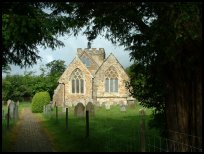
In 1757 its most famous resident John Fuller ( also known as Mad Jack ),
was born into one of the iron-founding families, who owned the mansion
adjoining the Church. The Family became famous for its iron furnace at
Heathfield which produced guns and cannons for the navy, and the forge
at Burwash Weald which produced a wide range of implements. Mad Jack
was one of the great English Eccentrics, a famous politician and patron
of science and the arts, who enjoyed building follies. The village of Brightling in East Sussex is a small farming community
settled soon after the Saxon invasion of 475, the location
of the village is probably lower down the hill from the
original settlement which was a fortified point on the top of the
hill nearer the current Jack Fullers Observatory.
In 1757 its most famous resident John Fuller ( also known as Mad Jack ),
was born into one of the iron-founding families, who owned the mansion
adjoining the Church. The Family became famous for its iron furnace at
Heathfield which produced guns and cannons for the navy, and the forge
at Burwash Weald which produced a wide range of implements. Mad Jack
was one of the great English Eccentrics, a famous politician and patron
of science and the arts, who enjoyed building follies.
Brightling has a collection of follies built by
Mad Jack , these consist of :-
- Brightling Needle - a 40 ft high obelisk
built on the top of the hill at Brightling,
used as a beacon point during the Napoleonic
Wars, and now by the ordinance survey as
the second highest point in Sussex.
- The Sugar Loaf - This was known as Fullers
Point, and was built to win a wager made
by Mad Jack , that he could see the Spire
of Dallington Church from his house, which
he could not.
- The Temple - This is a small temple/Summer
House, in the grounds of Brightling Park,
built to resemble a Greek Temple.
- The Observatory - This is built on the top of
the hill at Brightling, and for many years
famous for its instruments. This area is also
believed to be the place that Turner, the
landscape painter, did many of his paintings.
- The Watch Tower - Again built by Mad Jack ,
it was believed that it was built so that
he could watch the restoration of Bodiam
castle, which he had previously bought.
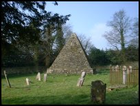
- The Pyramid - Built in the churchyard this was
to be Mad Jack Fullers mausoleum, it was only
allowed to be built by the Rector if a new
Public House, replacing the one opposite the
church, was to be built 1/2 mile away. This was
known until recently as the "Jack Fullers"
;. One final legend of the Pyramid, was that
Jack Fuller was buried inside, sitting up
wearing a Top hat and holding a bottle of
claret, this may or may not be true.
During Mad Jacks era, the famous artist, Turner
painted a number of country scenes of Sussex, these
were painted on and around Jack Fullers Estate.
The area under Brightling is a rich source of Gypsum,
which is mined under the hills, and transported to
Mountfield for processing via a 5 mile long conveyor
belt, resembling a giant centipede. |
|
 The best views from Brightling in East Sussex are firstly from outside
the church looking North West across the valley towards
Burwash. The best views from Brightling in East Sussex are firstly from outside
the church looking North West across the valley towards
Burwash.
Secondly from Jack Fullers Observatory, North to the North Downs,
and South West across the Pevensey Levels to the South
Downs at Eastbourne . |
|
 Brightling in East Sussex as a small village has few local services,
with the exception of the St Thomas a Becket C.E.
church. The nearest small towns are Battle about 6
miles to the South East, and Heathfield about 8 miles
to the North West. Brightling in East Sussex as a small village has few local services,
with the exception of the St Thomas a Becket C.E.
church. The nearest small towns are Battle about 6
miles to the South East, and Heathfield about 8 miles
to the North West.
The nearest trains and main buses can be caught at
Etchingham about 5 miles, and Robertsbridge about
4 miles. The nearest large town shopping centres
are in Hastings about 10 miles South East, and
Tunbridge Wells 17 miles to the North. |
|
| Brightling is shown as the red symbol on the map. |
|
|
Nearby Villages
(click on symbol to see the village page) |
| Village= | |
Town= | |
Recorded in Domesday= |  |
| |
|
|
Ashburnham |
(Last Iron Furnace in Sussex) | | 3.82 miles |
|
|
Battle |
(William the Conqueror prevails) | | 4.92 miles |
|
|
Bodiam |
(The finest ruined castle in the Country) | | 6.66 miles |
|
|
Bodle Street |
(White Horse on the roof) | | 4.27 miles |
|
|
Broad Oak |
(Smallpox at the Academy) | | 5.01 miles |
|
|
Burwash |
(The home of Rudyard Kipling) | | 2.47 miles |
|
|
Burwash Common |
(Roughest pub in the South East) | | 2.89 miles |
|
|
Burwash Weald |
(Roughest pub in the South East) | | 2.54 miles |
|
|
Cade Street |
(Jack Cade and the Kentish rebellion) | | 5.04 miles |
|
|
Cripps Corner |
(Home Guard surprises the Army) | | 5.66 miles |
|
|
Dallington |
(Custers Last Stand!) | | 2.16 miles |
|
|
Etchingham |
(The oldest Brass Weather Vane in the country) | | 3.59 miles |
|
|
Heathfield |
(19th Century Natural Gas) | | 6.25 miles |
|
|
Hurst Green |
(The Youngest Highwayman on record) | | 4.85 miles |
|
|
Mayfield |
(Saint Dunstan and the Devil) | | 7.16 miles |
|
|
Mountfield |
(17th Century Coal !!) | | 3.58 miles |
|
|
Netherfield |
(Village at the top of the Hill) | | 2.10 miles |
|
|
Penhurst |
(Beautiful yet Remote) | | 2.91 miles |
|
|
Punnetts Town |
(The Windmill on the Hill) | | 3.47 miles |
|
|
Robertsbridge |
(The Home of Modern Cricket) | | 3.56 miles |
|
|
Rushlake Green |
(Open Village and Nuclear Bunker) | | 3.96 miles |
|
|
Salehurst |
(Richard the Lion Heart's Gift) | | 4.46 miles |
|
|
Sedlescombe |
(Best gunpowder in Europe) | | 6.27 miles |
|
|
Staplecross |
(Mothers grudge hangs son) | | 6.04 miles |
|
|
Vines Cross |
(Cannons and Doodlebugs) | | 6.09 miles |
|
|
Warbleton |
(The Iron Man) | | 5.11 miles |
|
|
Whatlington |
(King Harold's Manor) | | 5.02 miles |
|
|


